
It’s clear to say that the history of Branson and the surrounding region is inextricably tied to the White River, the only significant waterway for most of southern Missouri and northern Arkansas.
The untamed river shaped the settlement of Branson and other towns in the region in the 1800s, both for good and for bad. Even today, it continues to be a major economic driver for the area. In the first years, the river provided an essential link for travel and commerce, but it also spread damage with its frequent flooding. In later years, after the river was dammed and as Branson became popular with tourists, the waterway and its lakes became attractions in their own right, drawing visitors at first by the dozens, and eventually by the millions.

Transportation and Shipping
In the first half of the 1800s, businessmen in the region were looking for ways to access the 722-mile-long White River and its eventual connection to the Mississippi River for steamboat and barge traffic.
Nearby Springfield was the largest settlement in the region, but it wasn’t built on a navigable river. Loggers, vegetable growers and cotton farmers were looking for ways to get their products to market, but they were only able to employ lightweight barges and keelboats to traverse the shallow upper White River.
In 1851, the Missouri legislature approved work to clear obstructions along the Missouri section of the White River and to deepen the river’s channel where possible. By 1853, steamboats were able to travel up the river from Arkansas as far as Forsyth, which had been named the seat of Taney County in 1845. As a result of the waterway connection, Forsyth quickly became a bustling settlement and center of travel and commerce for the region.
In the years after the Civil War, new shallow-water paddleboats were able to continue past Forsyth to the settlement that would become Branson and eventually on to the mouth of the James River, providing more of the region access to the downstream markets. But even then, the unpredictable depth of the river made ship travel beyond Forsyth difficult and unreliable.
The shipping and transportation link that the river provided for half a century was eventually replaced when the railroad finally came to Branson in 1906. This reliable connection for commerce and travel was what allowed Branson to flourish, leading to its incorporation as a city in 1912.
The First Dam and Lake Taneycomo
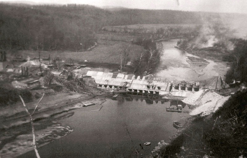
Just five years after the arrival of the railroad, the White River was impounded upstream from Forsyth by the construction of Powersite Dam, the first dam on the White River and the first hydroelectric plant in the central United States.
Branson began to thrive during this period. The city’s train station served as the railhead for the construction materials needed for Powersite Dam, where supplies were off-loaded and placed on barges that were then floated downstream to Powersite.
Branson Trivia:
Folklore has it that when workers at the Branson train station unloaded crates of supplies bound for the new Powersite Dam, many were stamped with the shipping address “TANEY CO MO,” short for “Taney County, Missouri.” Workers began referring to the lake by this name, and it was never changed.
While Powersite Dam meant the end of travel and shipping on the upper White, it also ushered in a new era of fishing, recreational boating and tourism that eventually benefited Rockaway Beach, Branson, Galena and other towns upstream.
Lake Taneycomo still looked like the White River in many ways, though the water was deeper and slower than before. The new lake started to become a tourist draw, but it was most notably promoted by outdoorsman and theater owner Jim Owen. Starting in 1935, Owen began organizing $2-a-day float trips on Lake Taneycomo that drew both everyday people and Hollywood-types like Paul Henning, Charlton Heston and Gene Autry.

A former newspaperman and a marketing genius, Owen labeled Branson “The Float Capital of the World” and used his connections to garner coverage in magazines like Field & Stream, Sports Afield, Life and the Saturday Evening Post.
Owen’s trips continued until 1958, when Table Rock Dam was completed. But Owen’s efforts to bring visitors to the area, combined with interest in Harold Bell Wright’s “Shepherd of the Hills” novel, had firmly established Branson as a tourism destination.

Taming the Mighty White
The frequent and devastating flooding along the White River and its tributaries had been a constant problem for settlers in the Ozarks for more than a century. After the Great Flood of 1927 and additional floods in the 1930s, pressure mounted on the government to act. In the Flood Control Act of 1938, Congress approved the creation of a number of Corps of Engineers dams in the White River Basin that would provide flood control, generate electricity and provide recreation opportunities.
Over the next three decades, six Corps dams — Greers Ferry, Clearwater, Norfork, Bull Shoals, Table Rock and Beaver — were built on the White River and its tributaries. The six dams create a chain of lakes with more than 200,000 acres of water spanning southern Missouri and northern Arkansas. Except for Clearwater, all the dams generate hydroelectric power.
Two more planned White River watershed dams were to be built in Arkansas on the upper and lower Buffalo River, but pressure mounted from locals and conservationists to preserve the scenic river in the Ozark Highlands. Eventually the Buffalo was put under the protection of the National Parks Service and protected from development in 1972.
Even since the construction of the dams, the White River continues to remind residents that while it might be tamed, it won’t be totally controlled. Flooding has been significantly diminished in recent years, but it does still continue to be an ongoing concern in the region.
Since the White River dams and levees were built, the Corps of Engineers estimates that they have prevented $1 billion in flood damage to the area.
A Cold-Water Lake Taneycomo
Built seven miles upstream from Branson, Table Rock Dam changed the character of the White River at Branson yet again. Now impounded on both ends, Lake Taneycomo became a slow-moving, cold-water lake stocked with trout.
A 22-mile long lake with about 2,000 surface acres, Taneycomo makes up the eastern and southern border of Branson and still resembles the old White River in many ways. Below Table Rock Dam, the 48-degree Taneycomo headwaters are very shallow and are a popular area for trout anglers who wade out onto the lake’s shallow shoals. By the time the lake reaches Downtown Branson, the water warms several degrees and is typically 5-15 feet deep. When it reaches Powersite Dam, where it is eventually discharged into Bull Shoals Lake, the water warms significantly and can be up to 50-feet deep in places.
Scenic bluffs tower over Lake Taneycomo, and many species of wildlife call the lake home, including eagles, Great Blue Herons and waterfowl like ducks and geese.
